
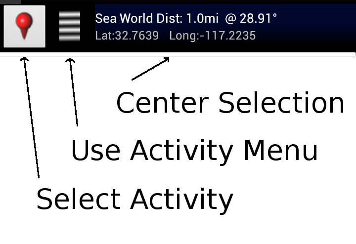
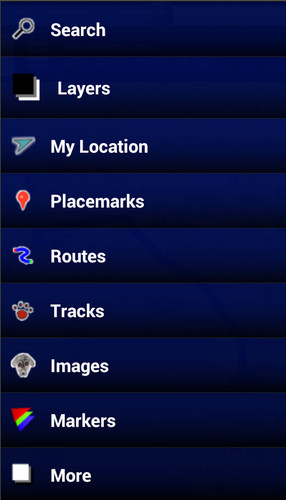


Activities are organized into the following categories:
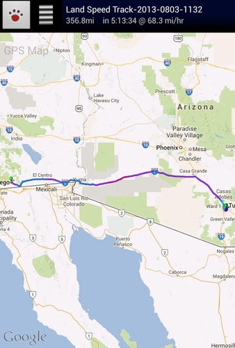
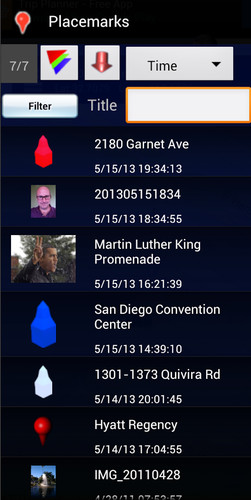
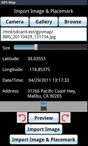
* Search - Find new Placemarks by address, or coordinates.* My Location - Center or mark your place quickly, toggle Real/Mock location, Search nearby, and Share your location.* Layers - Allows you to toggle the visibility of My Location, Placemarks, Satellite, Traffic, Track, and Route layers.* Placemarks - View list, Center, Change location, use as Mock location, Navigate to, Route to, Search nearby, Street View, and Share* Routes - View list, Change color, Details, Hide, Show and Share* Tracks - View list, Start/Stop Recording, Change color, Graph, Tour on Google Earth, View at Human, Land, and Plane speed, and Share* Images - View list, set Default for Marker, Import as a Marker, Import location from Image* Markers - View list, Edit/Delete/Hide/Show groups of Placemarks, Markers created for each Import* Compass Mode - All visible layers rotate instead of My Location arrow rotating towards north* Copyright - All the legal copyright and disclosure stuff* Data Management - Import/Export/Manage data * Help - A quick introduction, the FAQ, and links to other helpful content about GPS Map* Preferences - Adjust update time, long press time, the visibility of various items and featuresUse almost any image from your Camera, Gallery, or file browsing app to create a Marker for a Placemark on the map. Images containing location information can be imported as Placemarks with their image as the Marker on the map.
GPS Map has the following features:* Easy to search for a location by address, placemark name, or latitude, longitude.* Import/Export your Placemarks - GPSMap GPS, Garmin CSV, Geocode GEO, Google Earth/Google Maps KML,GPS Exchange GPX filesand TomTom ASCII* Imports the location and image from a photograph to create a Placemark on the map with the Image as the Marker * Able to view Placemarks, Routes and Tracks with Google Earth* Able to be taken to Google Street View for a Placemark (if available)* Able to use Placemarks to start a navigation app like Google Navigation* Export to Google Drive Fusion Tables with an active Gmail account* Creates Tours for Google Earth based upon your recorded Track
Works best with:* Google Earth, Google Maps, Google Street View installed.
GPS location service enabled.
Visit https://sites.google.com/site/wrightkeith/gpsmap/ for more information.