


Includes choice of map views; standard USGS topo or Accuterra shaded land use both marked with 250,000 miles of public land trails. ViewRanger is the only app with access to GPS enabled guided trails from outdoors book publishers Menasha Ridge & Wilderness Press. Each expert authored guide can be browsed and downloaded** to give you the trail, the full guidebook description & images stored on your device & ready to go. Once on the trail the app can be used to navigate with alerts if you veer off track. Also includes unlimited access to global open map layers, perfect for city running, cycling or sightseeing.
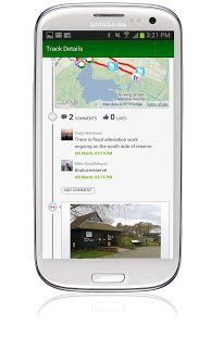
Plus free to join online community - My.ViewRanger.com: create your own routes, utilize those posted by experts or the community -“sync†to your devices. Upload your adventures, attach geotagged photo’s to create trip journals to keep or share.
"Overall I love this app.." Discovery.com Gear & Gadgets "..an impressive, easy to use and intuitive program for tracking and route-finding. Utah Outside “10 cool pieces of gear emerging in 2012â€. AdventurePost.com _______________________________________ MAPS FOR ALL TERRAINS ✔US topo maps - choose between detailed views with standard topo or shaded land use ✔Street and other mapping – choose between street, cycling and aerial imagery (global coverage) ✔Works even without mobile coverage - as maps can be stored on your phone (off-line) ✔Maps can be downloaded on the move** _______________________________________ RECORD YOUR TRIPS ✔Clearly mark the path you've taken on the map. ✔Save the recorded path of all your trips✔Upload your adventures to our online tool to share using Facebook or publish to the community✔Create trip journals with photos from your Flickrâ„¢ or Picasaâ„¢ accounts _______________________________________ ALL THE STATS YOU NEED ✔Real-time sport computer stats for over 30 metrics (i.e. speed, distance, time, elevation, pace, ETA, etc)✔customise screen views in text, dial or graph format✔Real-time on-screen map co-ord display (UTM WGS84, NAD27, ITM, Lon/Lat, etc)✔Supports imperial, nautical and metric units_______________________________________ EASY TRIP PLANNING USING APP OR WEB ✔Map layers include tens of thousands of marked trails (search by name)✔Download an expert guided route**✔Create your own routes using the in-app tool or our online planner ✔Import a route as a GPX file _______________________________________ FULL ON-SCREEN NAVIGATION ✔Active waypoint-based Navigation with on-screen visual guidance ✔Navigation alarms if you veer too far off track ✔Magnetic compass integration ______________________________________ LOCATION SHARING** ✔Share your real-time location with BuddyBeaconâ„¢ (a feature from ViewRanger)✔See the mapped location of your friends on screen✔Link your Twitterâ„¢ messages, photos and videos_______________________________________ SEARCH & LOCATE ✔Search by Place or Trail name using comprehensive offline gazetteer*** and online services. ✔Find location using map coordinate entry (ideal for Geocaching) ✔Real-time on-screen map coordinate display ✔Mark any important location as a Point of Interest (PoI)
* U.S.A. detailed terrain coverage is the contiguous United States plus Hawaii. Map layers are available for Alaska & Canada, but not at the same level of detail. ** requires wifi or mobile signal, may incur additional charges. ***free to downloadNeed more info? visit: www.viewranger.com. Any questions or feedback, please drop us an e-mail: support@viewranger.com